The Transport Data Management Service supports Authorities managing data collection, transfer, fusion and in making data useful and accessible for users and service providers. The service supports using data efficiently to enable better service delivery to end users.
Latest update: 21 April 2023
Transport Data Management
Advances in sensing and collection are producing more and better quality data transport data. Sources include in-vehicle connected devices, smartphones, roadside equipment and other assets, and third party or crowd-sourced data services.
Transport data is generated and collected in many ways – by transport service providers, manual collection, third-party applications and sensors (fixed and mobile).
Transport Authorities need timely, high-quality transport data for decision making to help them plan, operate and maintain transport networks more efficiently. For example: public transport route scheduling; traffic management; real-time event and schedule information; and operating transport hubs such as bus and train stations.
This use case focuses on the data management services that Authorities need and the interfaces to their systems. Some requirements will be similar regardless of the underlying technology used, so the focus as an Authority should be on compiling and, where appropriate, publishing accurate and complete data sets that are of use to services providers and the travelling public.
The transport data management service may provide either the foundation for other services or the means to integrate with systems and services outside the direct provision of transport illustrating that transport is a means to an end – the delivery of goods, retail, commuting etc. The Transport Systems Catapult estimated that not making transport data open and available could cost the UK £15bn by 2025. Additionally, duplicating existing data or not fully using existing data sources may cause extra costs for Authorities.
Managing, using, and sharing transport data does however introduce challenges that need to be managed, for example, privacy and security control. As a result, the use of such data is not mature despite the potential financial benefits.
CHALLENGES
Internal Challenges
- Authorities often lack the expertise to manage data internally, including creating data management strategies and procedures.
- Limited availability, access to, and integration of transport data – leading to inefficient transport strategies. For example:
- – Lack of data for smart parking and traffic management schemes
- – Air quality data to inform the general public or to inform air quality strategies
- Limitations to data sharing and collaboration within Authorities – between different departments or between different Authorities. Siloes need to be bridged, and where appropriate, data sets linked or fused.
- Inefficient management of data collection and processing assets. Late detection and identification of asset deterioration may lead to poor prediction and hence more expensive repairs or even replacement of the asset.
- Reluctance to write off sunk costs in physical sensors makes paying for “data-as-a-service” difficult to justify.
External Challenges
- Coverage/reliability of communication networks in some areas can limit real-time data availability.
- Limited social media penetration in some cases/demographics means a lack of end-users able to access data via these means, requiring alternative approaches.
Technical/ Commercial Challenges
- Some common protocols, data storage and data sharing approaches exist between Authorities and transport operators. However, these vary and sometimes conflict. It can be challenging to identify and choose the most appropriate specification for a specific application.
- Data that are not available in digital formats are hard to share and catalogue.
- No comprehensive, online transport-related data catalogue in the UK, although activities are underway to address this (The “Finding Transport Data” Service, led by DfT).
- Data security, firewalls and conflicting levels of access are confusing and create technical barriers that limit data exchange.
- Public sector data and data shared by the public tends to be open, but shared in different platforms which hinders linking data, or has quality constraints. Private datasets are not free to access but may be of a higher quality or have elements that are otherwise unobtainable. Contractual barriers may prevent fusing public and private data and then disseminating it.
High-level objectives
The Transport Data Management Service will support the following outcomes:
- The DfT’s Future of Mobility principles.
- Improved quality and efficiency of information dissemination helping Authorities make better, and well-informed management decisions.
- Improved road safety due to better planning from data availability and analysis from near misses, accidents and hot spots.
- Influence modal shift and behavioural change to sustainable transport modes and Active Travel.
- Asset management efficiency and hence fiscal savings due to the better maintenance planning from improved information and near ,real-time asset condition and state data.
Additional outputs are:
- Improve transport information storage, analysis, exchange and availability for other stakeholders including other Authority departments
- Service improvement for users due to more reliable and timely delivery of good quality information
- Some new revenue sources may be possible from services developed on the back of the improved and enhanced transport data although this is likley to be minimal.
- Real time data services implementation to help manage traffic congestion and network usage, and improve end-user awareness of disruptive events on the network.
- Improved and optimised services for disabled and vulnerable transport users through better information on travel patterns.
- Support integrated transport through fusion of digitalised information.
Policies potentially supported by the service
The Transport Data Management Service will support the following policies:
- Data digitalisation
- Asset management
- Road safety
- Land use planning
- Improving air quality and reducing noise
- Decarbonisation & electric vehicle charging
- Modal shift
- Active Travel
- Services for disabled and vulnerable road users
- Mobility on demand and efficient network use
Qualitative Benefits
The Transport Data Management Service can support the following benefits:
- Access to high quality information for all road users.
- Improved transport user experience.
- Modal shift from private vehicles.
- Improved productivity due to more informed and optimised journey choices.
- Better network intelligence due to better analytics and reporting, potentially reducing whole life costs of equipment.
Quantitative Benefits
The Transport Data Management Service can support the following benefits:
- Less costly asset management and increased longevity of assets.
- Reduced capital spends on owning roadside sensors and maintenance costs.
- More efficient network management due to real-time data availability, e.g. journey time information for all transport modes.
- Increase in road safety, reduction of traffic collisions, accident prevention due to early identification of hot spots and near miss locations.
- Improved traffic collision response time and clearance management time.
- Improvement in air quality and reductions in noise levels.
- Better coordination of incidents and events at a cross-authority and regional level.
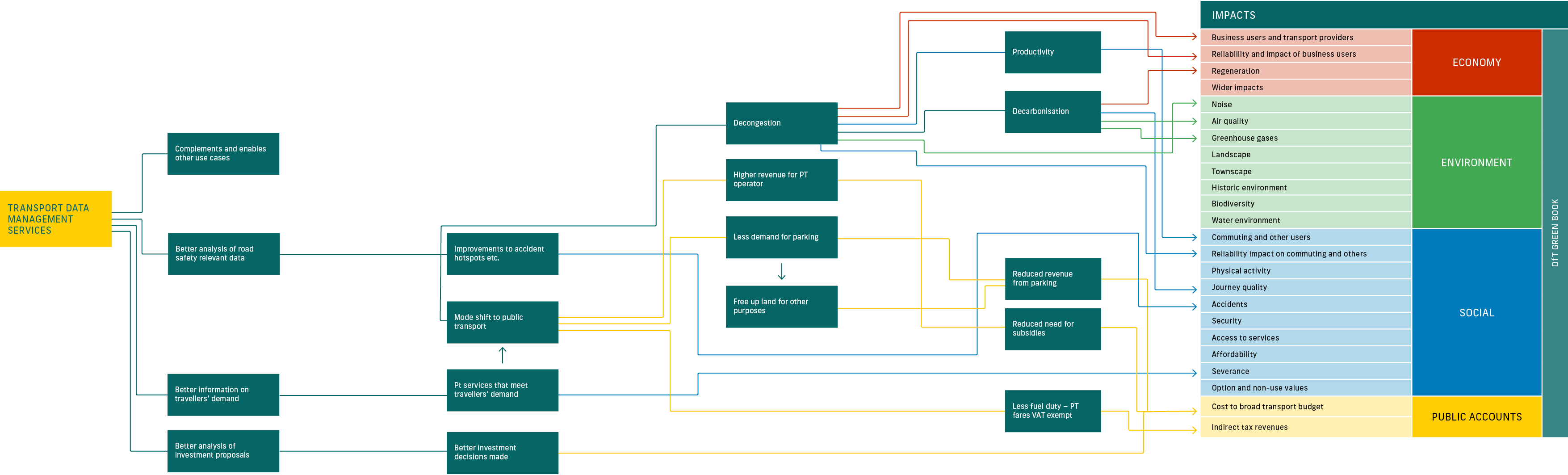
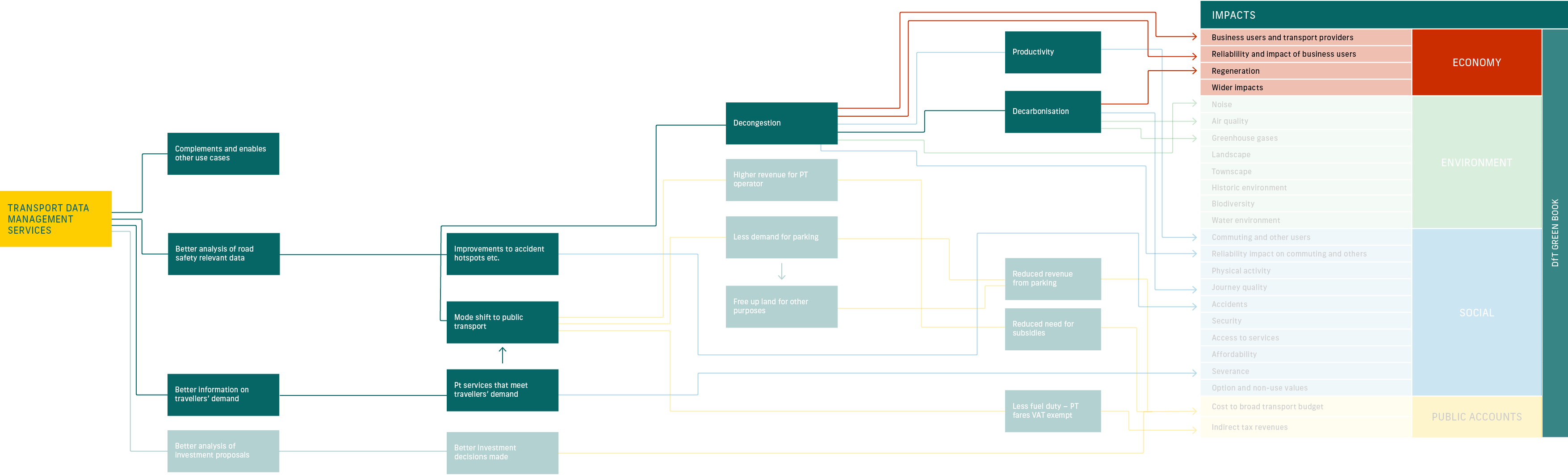
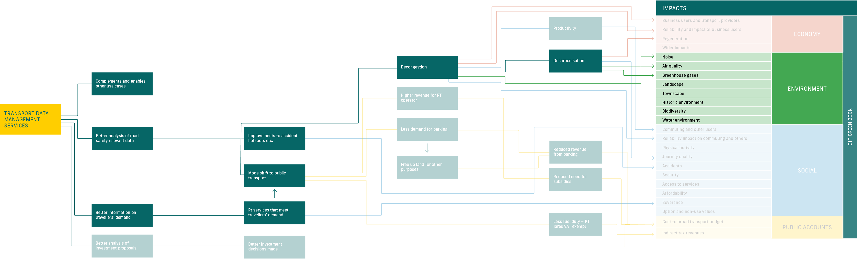
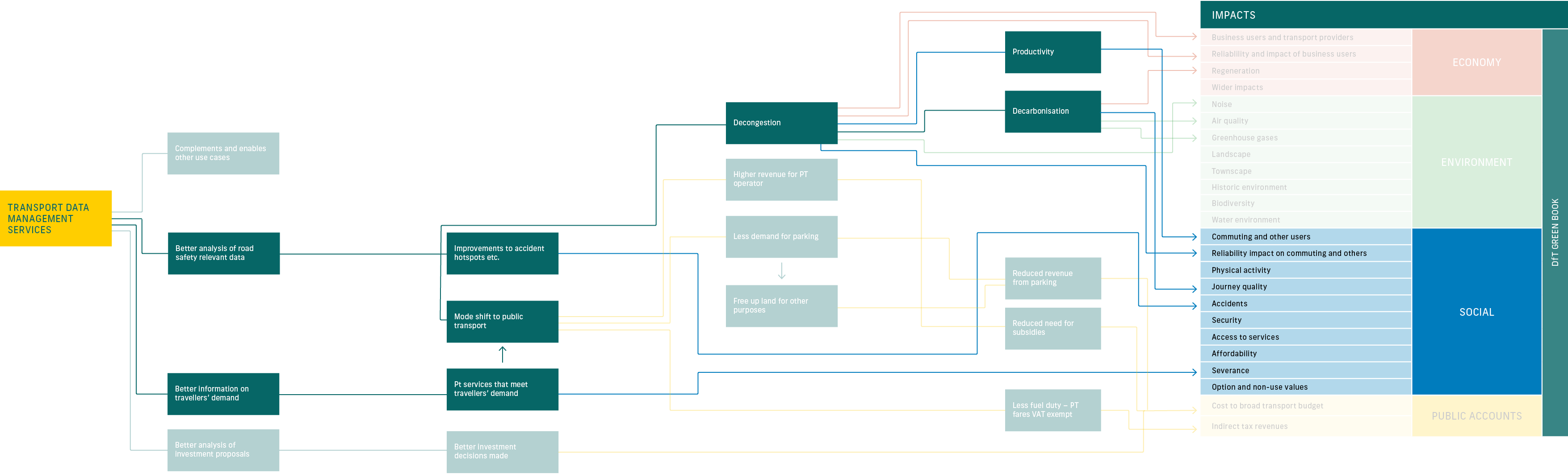
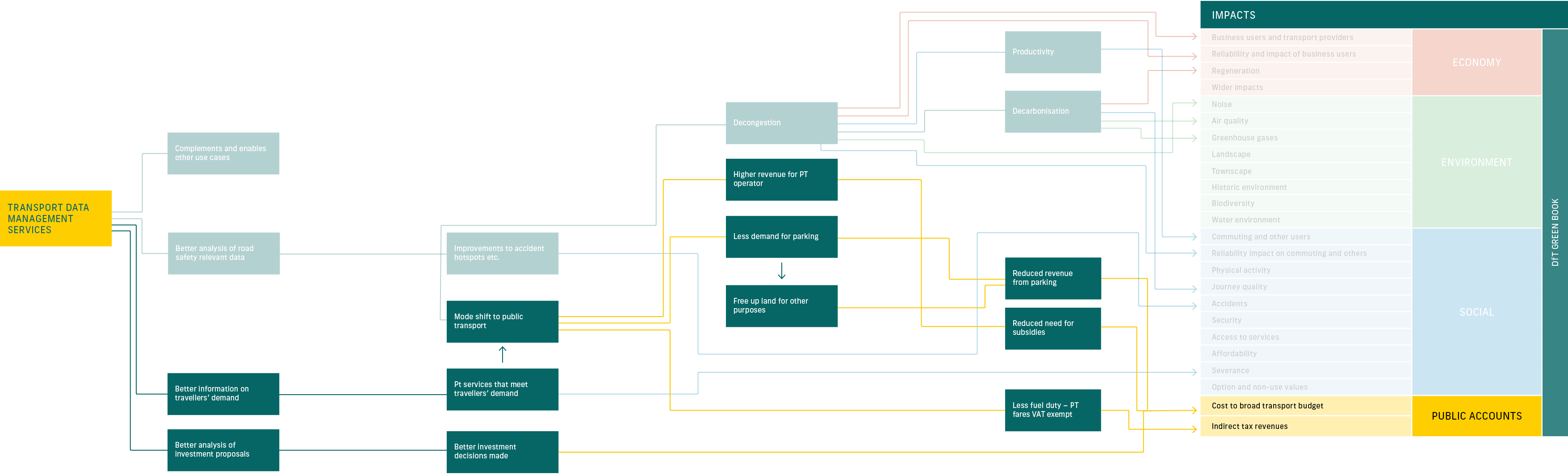
Figure 2 – The potential impacts of the Transport Data Management Service
View by impact type:
DRAG
Introduction
This section intends to support the development of plans and specifications by providing the following information:
- Actors: who need to be considered in the development of the system.
- Architecture and Data flows: showing how administrators and users interact and use the system, to help identify and develop the needs and specifications of the system.
- Standards: that are important and how these are used in the context of this use case.
- Possible future developments: in practices and technology that may provide opportunities in the future.
Actors
The key is the interaction between the service and the actors (any user or system that interacts with the service). The following actors need to be considered in the service design:
- Data Manager / Administrator within Authorities – The data manager is responsible for the management of data collection, transfer, fusion, storage, publication, and disposal. They need access to software to generate data, as well as creating digital and data capabilities within their organisations by upskilling their existing staff or recruiting additional, new staff. Legal roles such as Data Controller need to be fulfilled for example if Personal Data is collected (e.g. vehicle registration marks)
- Transport User – These are members of the public or businesses that need transport data to support their interaction with the transport network. Transport users include the emergency services to help their vehicles navigate through the network.
- Data User within local, regional, and central government, as well as sub-national transport bodies – The bodies and Authorities responsible for transport management or local politicians influencing transport policies.
- Transport Operators – Public Transport Operators host and publish their data, although, for busses this will be increasingly part of the Bus Open Data Service. Includes taxi operators and mobility on-demand providers; Non-public transport operators (such as freight and fleet) and other commercial road users.
- Data collection service providers – This includes third party systems who may also own the data they provide (e.g., WAZE, O2, INRIX, Google, TOMTOM, HERE, Citymapper), as well as new service solutions from start-ups providing specific or unique data sets.
The journey of the user through the system is key to and the focus of the description of this Use Case rather than the processes that a Local Authority would follow to develop a transport data management system.
Architecture and Data Flows
The transport journey is considered as one journey on a single vehicle – not a trip from A to B which may include more than one mode of transport. Journey planning itself may give multiple journeys and options.
The data flows are illustrated in Figure 2 – Idealised Journey for Surface Transport User and Figure 4 – Idealised Transport Data Management Service Architecture from Data Manager’s perspective.
The data requirements and data flows are tabulated in Figure 3 – Data Requirements for Idealised Journey for Surface Transport User and Figure 5 – Data Requirements for Idealised Data Manager/Administrator Activities.
Figure 2– Idealised Journey for Surface Transport User

Figure 3 – Data Requirements for Idealised Journey for Surface Transport User


Start
Journey Search
Start Journey
Travel
Journey End

What the surface transport user needs
- As a surface transport user, I need to search and identify the best travel option for my journey (based on preferences such as the route, journey time, cost, accessibility, and weather), so that I can make an informed decision of the type and timing of travel I should make. If my journey involves payment I may wish to know how, where and when I can pay.
- As a surface transport user, I need to know where to start my journey, so that I can start my journey in a timely manner.
- As a surface transport user, I need to know the real time and predicted network condition, so that I can replan my journey and communicate my new ETA.
- As a surface transport user, I need to know the real time and predicted network condition and other non-traffic information (weather), so that I can replan my journey and communicate my new ETA, and consider new options, if needed.
- As a surface transport user, I need to know if I have arrived at the right location and on-time.
As a surface transport user, I need to know if I can give feedback regarding the trip and information provided to me.
What the system needs from the surface transport user
- Confirm user’s journey start and end location
- Confirm user’s expected departure time or arrival time
- Confirm user’s services and accessibility requirements
- Confirm user’s journey preference
- Confirm user’s arrival at start location and time
- Confirm user’s journey and if there are any changes to trips and preferences
- Confirm user’s location
- Confirm user’s progress in the network and whether there are changes to the journey midway
- Confirm user’s changes to journey preferences
- Confirm user’s destination location and arrival time
- Feedback on journey and information
Data requirements
- Travel options including mode choices (public transport data), route information (departure time, arrival time, fuel), route restrictions (height, width, etc.), route charging (congestion charge, tolling, emission zone)
- Historic traffic status of the network
- Current traffic status of the network
- Future (predicted) traffic status of the network
- Accident data
Planned roadworks data - Transport schedules
- Network routes and interchanges
- Diversion data
- Pollution data
- Weather prediction
- Special events information (that may impact the plan)
Accessibility information - User preferences (profile)
- User vehicle characteristics
- Public transport data
Signal timing information - Historic traffic status of the network
- Current traffic status of the network
- Future (predicted) traffic status of the network
- Special events information (that may impact the plan)
- Unplanned roadworks data
- Dynamic diversions
- Accident data
- Hazard and weather data
- Public transport data
- Dynamic diversions
- Accident data
- Hazard and weather data
- Signal timing information
- Events data
- Current traffic status of the network
- Future (predicted) traffic status of the network
- Journey end location and time
- Journey/trip log
- User’s feedback data
DRAG
Figure 5 – Data Requirements for Idealised Data Manager/Administrator Activities


Start
Data collection
Data transfer / interface
Data fusion
Data storage
Data publish
What the data manager / administrator needs
- Reliable set of sensing devices
- Vetted and reliable set of data providers
- Defined common standards for data (data format, model, exchange characteristics, etc.)
- Defined common approach for location and time tagging of data
- Common transfer protocol
- Integrated interface
- Centralised service (all information in one package)
- Control of all assets that are able to change the traffic state
- Ability to obtain the right data in the right time
- Ability to set priorities for data transfer rates and needs depending on variable operational requirements
- Ability to combine multi-sourced data through a common referencing model
- Ability to validate different data sets and assign weighting or quality scoring
- Ensure fused data comply with privacy regulations and policies
- Understanding of the different data sources (metadata)
- Safe and reliable storage of data with ability to set different access levels
- Ability to store raw and processed data sets
- Ability to monitor and receive updates about the status of the different data feeds and usage of the data
- Ability to generate reports (automatically and manually) about data usage, and analytics outcomes
- Ability to evaluate the impact of data analytics-based decisions
What the system needs from the data manager / Administrator
- Compatibility and validation specification of data sources
- Alert notification specification (time lag, responsible contact)
- Defined performance criteria (data capture percentage requirements) and importance level of every data feed
- Data sharing guidelines and requirements (Log file formats)
- Classification of data based on priority levels
- Anticipated data volumes from different data feeds
- Required data transfer method for data feeds (over wired or wireless communication)
- Data type (raw vs processed) and transfer rate (continuous feeds, at set interval, triggered by events) from each data feed
- Data frame specification
- Standardised communication between different parts/elements of the system
- Define and agreed data reference model
- Desired data format
- Data fusion approach
- Data storage specifications (volumes, storage location, mechanism)
- Data access specifications
- Data retention requirements
- Security specification
- Authentication specification
- Authorised user list
- Data requirements
- Data format requirements
- Data refresh time
- Data summary requirements, thresholds, outliers
Data requirements
- Traffic and transport data from internal fixed infrastructure
- 3rd party traffic data (e.g. crowd-sourced data, connected vehicle data, smartphone apps)
- Data from different transport modes
- Data about impactful events on the road network such as weather and roadworks
- Provider’s data capture rates
- Providers failure’s information (failure type, time to respond repair)
- Performance indicators
- Equipment data transfer specification
- Data transfer protocol information
- Asset state, real time updates
- Desired state of each asset
- Current state of assets
- Operator responsible for each asset
- Status of data transfer links
- Status of 3rd party data feeds
- Planned maintenance that has impact on data transfer
All the data in the “Collection of data” column
- Status of data storage
- Record of data backup activities
- All the data in the “Collection of data” column
- Data analytics outcomes
- Decisions built on data fusion and data analytics outcomes
- User feedback data
- Data about usage of the available transport (raw, fused, analysed)
- Report recipients list
DRAG
Interfaces
Interfaces between systems and services will depend on the specific design and the boundaries with other systems and services.
The general principle is that interfaces should be specified to use standards and protocols wherever they are available to support integration.
Making the most of data that is available and making the most of your data
Authorities have access to several existing DfT centralised data services for:
- Streetworks and permits for roadworks at Streetmanager which must be used by to:
apply for street and road work permits- – assess permits
- – notify live works
- – record inspections
- – add reinstatements (after work has been completed)
- – https://www.gov.uk/guidance/plan-and-manage-roadworks . The website enables Authorities to publish and access timetables of streetworks and disruptions with neighbouring Authorities.
- – Commercial services such as one.network provide a validation and publication service of the data to sat nav companies further adding value.
- Bus location, tariff and bus stop location data is all now centralised in the Bus Open Data Service (BODS) with free to access live bus location data and free tolls for data analysis. https://www.gov.uk/government/collections/bus-open-data-service has more guidance. Note that the data is not yet being used for managing bus priority but it is being considered.
- – DfT has published guidance on how to share Authority Transport Data: (insert URL )
- The emerging “Find Transport Data” service (previously called the National Access Point) will be a catalogue where Authorities and other providers publish a register of their data and how to access it.
Sat Nav companies provide websites for Authorities to correct map errors: https://support.google.com/maps/answer/10271004, https://help.tomtom.com/hc/en-us/articles/360013960619-About-MapShare-reporter, /www.ordnancesurvey.co.uk/business-government/public-sector-geospatial-agreement/error-reporting-improvements
Other work is underway on centralised services for Parking (The National Parking Platform) and for Digital Traffic Orders.
Standards
The European Commission aims to standardise ITS data for the optimal use of road, traffic and travel data. Including defining mechanisms for the exchange and shared use of data between the stakeholders (relevant public Authorities and service providers). More specifically, standards are required which define information and data structures and dictionaries in the field of road, traffic and travel. For example: road traffic event information, operator-initiated actions, road traffic measurements and travel time data. The exchange standards include both centre-to-centre (C2C) and centre-to-roadside communication.
It is important to note that road traffic data is not limited to the systems provided by Authorities and service providers, but is part of many information chains along the user’s journey. There is on-going cooperation of international working groups to align their standards on the development of data exchange for Public Transport, Traffic and Traveller information, and integrated transport information, management and control. There is currently no work in the area of centre-to-roadside communications. However, the following standards are relevant for Data Management Services that are either published or in development.
- Standards for Traffic Management Data Exchange (DATEX II). DATEX II is a long-standing European initiative defining the European Standards for the terminology, encoding and exchange of several forms of traffic management data. The DATEX II website provides guidance, downloadable data models and schema, and toolset support.
- Transport Protocol Experts Group (TPEG) is a format for telematics data. TPEG provides a standardized method for the delivery of traffic and travel information that is language-independent and compact. It uses a variety of ways to reference locations, while the main use is for cars, TPEG is extensible and can be used by many types of applications. TPEG is coordinated and controlled by the Travelers Information Services Association. (TISA website). The standard contains information on traffic events, traffic flow, fuel, parking, and weather.
The ISO/TS 21219 series provides the generation 2 (TPEG2) protocol suite for traffic and travel information. - The National Transportation Communications for Intelligent Transportation System Protocol (NTCIP). The NTCIP is an industry-wide, standard data communication protocol designed to ensure that the electronic traffic control systems and messaging systems produced by computers and different suppliers are interoperable.
Possible Future Developments
Ongoing developments to technology will change the way that users receive and access information and extend the data sources available to Authorities for monitoring and analysing their network.
The transport data management service is the foundation of and enabler for other smart street services. Future development will be driven by domain and mode specific developments, such as new centralised services which will influence an Authority’s approach to access and use data across the transport network. As more data sources become available and more service providers use the data, and the value the data management service brings will increase.
Existing sensors such as loops will continue to deliver much real-time data. While conventional ITS systems include authority controlled sub-systems (roadside equipment, traffic control centres), a central focus of current development is gathering information from road vehicles, both sensor-derived, real-time data from vehicles themselves and data available from smartphones and other personal devices travellers carry with them.
Many commercial companies and vehicle makers already offer services including feeds of connected vehicle data ranging from journey times to pothole reporting and parking availability.
Mobile location data is generated, collected, and utilised by organisations like Google to enhance their services (e.g., mapping and navigation, search, etc.).
Lower resolution mobile information can be collected based on cell phone tower connections, and from Wi-Fi network and Bluetooth connections – a process known as “sniffing”. This is used in locations such as Newcastle thorough the city’s Wi-Fi network and in commercial data feeds from mobile operators and data companies.
When considering the use of data sources, Authorities should consider:
- Using centralised services such as BODS wherever possible as they are well supported and often free.
- Making use of existing platforms for new deployments in different areas:
- – Rather than rolling out a dedicated platform for each use case, Authorities should build off existing networks to support multiple applications and enable data re-use.
- Adopting standards to give more freedom in choosing the appropriate vendors according to their needs
- – For example: several services such as BODS reference NeTex1 (CEN/TS 16614-3:2015) are available for fares data.
- – Ensuring data is exchanged and published to standards wherever possible to maximise the potential for consumption of the published data.
- – Promoting access to ‘open’ data in standard formats. This allows synergies and integration of the data in other services.
- – Providing opportunities for developers to trial new service to continue to learn and develop their capability to engage is this arena.
- Developing and making available high-quality data that makes it easy for service providers to find and use, so making it available to the public
- – Focusing on service quality and service levels so data feeds can be relied upon and can be dependable.
- – Using the “Find Transport Data” service when it becomes available.
- Developing a cloud-first strategy for data storage
- – Cloud technology tends to be more flexible and scaleable.
- – Reduces the costs of maintenance and security of using owned servers. infrastructure